

Gujarat: Natural Hazards and Disaster Management
- The state of Gujarat has been facing the most overwhelming natural disasters in the last decade. These natural disasters have not just caused colossal destruction but have also paused a stop to various development programmes. The unique geo-physical setting of the state makes this region highly vulnerable to natural disasters like droughts, floods, cyclones, earthquakes, etc. In last decade either the whole state or a large part of it has witnessed extreme climatic conditions or drastic natural events.
- The state has suffered from the severe droughts and acute scarcity situations, desertification of swathes of the state where economic ravages continuously the fragile ecologies and environmental degradation. Moreover, drought, epidemics, floods, cyclones, earthquakes and other human-made disasters dominated the last decade. In the year 1994 Surat suffered heavily due to pneumonic plague. Drought years followed by heavy rains caused floods in the state. In 1997,12 districts of Gujarat were flooded, especially in North Gujarat, in 1998 South Gujarat and particularly Surat city was flooded and a cyclone struck Kandla port and other coastal areas causing colossal destruction.
- The next year was again a cyclone and scarcity year, and in year 2000 the economic capital Ahmedabad was flooded, causing economic losses in thousand crores. The year 2001 witnessed the most devastating earthquake and the next year 2002 communal riots. These disasters have not just resulted temporary economic losses and casualties, but have put a brake on the development process in the state since resources earmarked for development are diverted to meet the needs of disaster and its aftermath.
- During the last 40 years from Gujarat’s inception, 23 years have been drought years. Starting from 1850, 24 cyclones struck the state and 9 earthquakes out of which three has been highly devastating. South Gujarat and the central part continue experiencing the demon of floods. Gujarat is having concentration of chemical industries, particularly, in a stretch of 400 kilometers from Ahmedabad to Vapi, known as the ‘Golden Corridor’. Ankleswar in Bharuch district is Asia’s largest chemical zone. The State being highly industrialized and looking at its multi-hazard industries, it is quite evident that these have the potential of causing multiplier ruinous effects. The state has a large number of chemical and pharmaceutical industries, petroleum industry, and major ports, which have, added to the state’s vulnerability to catastrophes. All through the recorded history, the state has endured natural disasters increasingly claiming more lives and causing disabling injuries and tremendous economic losses. In spite of improvements in prediction techniques, advances in telecommunications and better efficiency in emergency relief and rehabilitation, natural disasters seem to be occurring frequently.
- On account of its geographical position, climatic and geological setting, gujarat has had a fair share of disasters of varying magnitudes from times immemorial. Non-availability of moisture during the greater duration of the year and majority of the region being arid and semi-arid makes the state’s landmass vulnerable to drought; on the other hand, heavy concentration of rainfall within a span of a few rainy days in large parts ofthe state causes heavy run-off, leading to high floods and water-logging problems. The tectonic movements, ofthe plates of the Indian subcontinent make the state vulnerable to severe seismic disturbances and the cyclones rising from the Arabian Sea frequently attack the 1600 km coastline ofthe Saurashtra peninsula and Kutch.
- It is apparent by now that the Gujarat is vulnerable to multiple hazards having multiplier effect. Out ofthe total 25 districts, the districts of Ahmedabad, Bharuch, Surat and Valsad are prone to all four hazards. Other districts except Rajkot are prone to three hazards. Thus, more or less the entire state is prone to various kinds of natural hazards and more people are now vulnerable than ever before. It has also become apparent that, on the one hand, particular communities are periodically exposed to the same hazards, on the other hand, hazards are striking areas where they are not expected and also in higher magnitude. The industrialized part as well as the coastal area having major ports and gigantic industries hold enormous potential of devastation owing to the multiplier effect of natural phenomena that can strike on these units/areas.
- The Kandla port was affected very badly during the cyclone of 1998. The port handles chemicals that may prove to be extremely hazardous if any calamity strikes. While looking at the cyclone hazard map, it is apparent that starting with Ahmedabad district to Kutch, starting from the shore to some kilometers towards land, the whole ofthe coastline is in very high damage risk zone B (50m/sec wind speed).
- Areas from Kheda district to Valsad, Silvassa and Dadra and Nagar Haveli, fall in the moderate risk zone (47m/sec wind speed). Thus, all the ports and industries falling in this belt are highly vulnerable to severe damages. The Earthquake Hazard Maps and the Flood Hazard Maps also indicate the state’s physical vulnerability. The Earthquake Hazard map has indicated the underlying principle deep-seated faults, and major and minor faults. Though, the Flood Hazard Map has not indicated the low lying areas, it can be very useful with locally available data of low lying areas and other geographical characteristics are used for any further planning. From the earthquake hazard map of Gujarat, it is seen that almost whole of the State lies in seismic zones of probable Intensity IX (severest) to VII (moderate) on M.S.K. Intensity Scale.
- The Kutch district, which has 80.3 per cent of its areas in intensity IX Zone, has been subjected to earthquakes in India. Kutch has a long-standing history of earthquakes. Gujarat is located in the Himalayan collision zone where the Indo Australian tectonic plate slides under the more northern Eurasian plate in a predominantly northern direction at a rate of 2 centimeters per year. This process compresses the region and the crust is being forced into folds of young deposits. This process causes active fault lines below the surface of the ground known as “blind thrust faults”. These faults do not rupture the surface, but create rolling hills. There is evidence of at least four of these hill patterns in Gujarat.
- Most of the coastal areas of the state fall in the 50m/s (180km/h) wind velocity zone, other areas fall into 47m/s, 44m/s and 39m/s velocity zones. The state has experienced 24 cyclone crossings from 1850 to 2000 out of which 11 have been severe cyclonic storms. The probable maximum surge height that can be expected to strike the coast is as much as 5m above concurrent tide level. During the cyclone of 1998 there have been incidences of this height being 8 meters. A large proportion of the buildings in the state run the risk of moderate (M) to very high (VH) risk from high velocity winds. The nine districts that fall in the high-risk zone with cyclones partly or fully are Junagadh, Rajkot, Jamnagar, Amreli, Bhavnagar, Kheda, Surat, Bharuch and Kutch.
- Gujarat is moderately prone to the floods hazard. The Flood Hazard Map shows that the flood prone areas are mainly along the principal rivers in the state. The problems associated with these rivers are mainly inundation of areas due to spilling ofriverbanks and inadequate drainage at places and erosion of banks. The Narmada, Sabarmati and Mahi basin frequently experiences river floods due to heavy rains in the upstream, and the Saurashtra region experiences floods due to excessive rainfall as in the years 1982, 1983 and 1988. While referring to relative importance of different ecological disasters for Gujarat, Earthquake, though envisaged once in 50 years, can create the most ruinous effects.
- Cyclones and floods with comparatively less vulnerability of the State can be dealt effectively. Earthquake with no warning and with most of the State’s area under Zone-V to Zone-Ill, the risk involved is much higher Moreover, the Golden Corridor of Gujarat, though lying In the Moderate Damage Risk Zone (MSK VII) has the potential of great economic losses even with lower intensity earthquakes. Major Parts, the Golden Corridor and the Silver Corridor of Gujarat can prove to be ruinous if their potential of multiplier hazard is overlooked while planning out long-term mitigation and preparedness measures. The increase in damages due to disasters is being brought about by concentration of people in disaster – prone areas. Why this is occurring can be the topic of a volume all on its own. However, in terms of disasters, what it translates into is the understanding ofincreasing and changing vulnerability.
- Brief about common hazards in Gujarat
Cyclone:
- Gujarat falls in the region of tropical cyclone. With the longest coast line of 1600 km in the country, it is highly vulnerable to associated hazards such as floods, storm surges etc.
- Most of the cyclones affecting the State are generated in the Arabian Sea. They move North-East and hit the coast particularly the Southern Kutch and Southern Saurashtra and the Western part of Gujarat.
- Two cyclonic storm seasons are experienced in Gujarat: May to June (advancing southwest monsoon) and September to November (retreating monsoon).
- Drought:
- Gujarat is one the chronic drought prone State of India, with an average annual rainfall about only 700 mm with more than half of the Talukas of Gujarat receiving rainfall within the range of 200-400 mm.
- Substantial portions of the State are arid to semiarid. With large parts of North Gujarat and Saurashtra having no sources of alternate irrigation, drought vulnerability increasing with groundwater overexploitation. Falling water tables put added stress on crops and water supplies.
- Flood:
- The climatology of Gujarat is influenced by the Arabian Sea in the West and three hill ranges along its Eastern border. A long coastline makes parts of arid Saurashtra and Kutch occasionally experience very high rainfall. These occasional heavy rainstorms are responsible for most of the floods in the State. While the Northern part of the State is mostly arid and semi-arid, the Southern part is humid to sub-humid. Extremes of climate, be it rainfall or temperatures are quite common in this region.
- All major rivers in the State pass through a wide stretch of the very flat terrain before reaching the sea. These flat lowlands of lower river basins are prone to flooding. Cities like Ahmedabad, Surat and Bharuch are located on the flat alluvial plains of large rivers.
- Concentrated runoff resulted by heavy rainfall cause flash floods in the small river basin of Saurashtra and Kutch because of their fairly impervious catchments (rocky or black cotton soils) and steep sloping upper catchments.
- Earthquake:
- Whole of Gujarat region has earthquake hazard of different levels from moderate to high as zones III to V are assigned to it in the seismic zoning map of India.
- In the Seismic Zoning Map of India the Gujarat region is divided into three zones. Kachchh region (about 300km x 300km) is assigned zone V where earthquakes of magnitude 8 can be expected. A belt of about 60-70km width around this zone covering areas of North Saurashtra and areas bordering Eastern part of Kachchh are assigned zone IV where intensity VIII can be expected mainly due to earthquakes in Kachchh and some local earthquakes along North Kathiawar Fault in Northern Saurashtra. Rest of Gujarat lies in zone III where intensity VII can be expected due to moderate local earthquakes or strong Kachchh earthquakes.
- Tsunami:
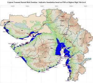
- Gujarat is prone to Tsunami risk due to its longest coastline and probability of occurrence of near and offshore submarine earthquakes in the Arabian Sea.
- Makran Subduction Zone (MSZ) -South West of Karachi is an active fault area which may cause a high magnitude earthquake under the sea leading to a tsunami.
- In past, Kandla coast was hit by a Tsunami of 12 mtrs height in 1945, due to an earthquake in the Makran fault line. Tsunami prone areas in the State include coastal villages of Kutch, Jamnagar, Rajkot, Porbandar, Bhavnagar, Anand, Ahmedabad, Bharuch, Surat, Navsari and Valsad districts.
- Gujarat State Disaster Management Authority
- The Gujarat Government has enacted the Gujarat State Disaster Management Act 2003 and in accordance with the provisions of this Act the Government vide its GR dated 11.8.2003 has constituted the Gujarat State Disaster Management Authority effective from 1.9.2003. The Hon’ble Chief Minister is the Chairman of GSDMA.

- The Government of Gujarat has adopted a multi-hazard holistic approach to disaster Management with a focus on reducing risk and vulnerability through policy, legislation, capacity building, education and communication to mitigate the impact of disaster and achieve better preparedness.
Disaster Risk Management Programme (DRM Programme):
- Adopting the proactive Preparedness and Mitigation instead of the traditional model of Relief and Rehabilitation GSDMA implemented Disaster Risk Management Programme (DMP) in all 33 Districts and 8 Municipal Corporations of the State. The DRMP aims at strengthening the community, local self government and administration to be aware and prepared to manage disasters. The activities under DRMP include preparation of Disaster Management Plans at all levels (Village, Taluka, City, Municipal Corporation & District), capacity building activities for stakeholders like orientation programmes, training, practical demonstrations and awareness generation activities. The plan and preparedness is also regularly assessed through periodic mock drills and mock exercises. GSDMA has also established an online portal of disaster repository named as State Disaster Response Network (SDRN) which contains information on available resources of village, taluka and ULB level for prompt disaster response.
- Training Programme on Operation of Satellite Phone: To strengthen the disaster communication system in the State, GSDMA has provided satellite phone to the district administration. GSDMA conducts one such training programme each year before onset of monsoon season with State Emergency Operation Center (SEOC) for the responsible officers for handling and operations of satellite phones at State and District level. Recently GSDMA has procured 9 satellite phones for 7 new districts & other Government offices.
- State Emergency Operation Center: GSDMA has constructed the State Emergency Operation Centre (SEOC) which shall be the state’s central command and control facility for emergency preparedness disaster management functions in an emergency situation to restore normalcy in the affected areas within shortest possible time. The primary objectives of the SEOC is to ensure saving of time between reception of disaster warning and dissemination, enhancing warning capabilities and support the decision making process in a disaster situation. Hence, GSDMA has proposed to establish an Information and Communications Technology System (ICTS) for effective disaster response.
- District Emergency Operation Centers (DEOC) : The Gujarat State Disaster Management Authority has already taken active measures for the construction of ‘District Emergency Operation Centers’ and to make it well equipped in all the 33 districts of Gujarat. Such centers are already functioning in 26 districts and the construction work at 7 new districts are under progress.
- Emergency Response Centers (ERC): The State Government of Gujarat has established five such Regional Emergency Response Centers (ERCs) at strategic locations across the State viz., Rajkot, Vadodara, Surat, Gandhidham & Gandhinagar to respond effectively within the golden hour of occurrence of a disaster. A tripartite MoU between Municipal Corporations/District Collector, Commissioner of Relief and CEO-GSDMA has been prepared for the operation and maintenance plan for the ERCs. The construction work has been completed in all the ERCs. MoU has been signed for all the five ERCs i.e. Rajkot, Surat, Vadodara, Ahmedabad and Gandhidham for operation and maintenance.
- Taluka Emergency Operation Center (TEOC): TEOCs are a part of the Information and Communications Technology system for GSDMA. The TEOCs are extended arms of the State Emergency Operations Centre and some of the critical EOC operations are transferred to the Taluka EOC. It is planned that 29 Taluka Emergency Operations Centers shall be created in different taluka in the state of Gujarat in which construction/equipping of TEOCs at 9 taluka is completed.
- School Safety: Gujarat State Disaster Management Authority is determined to conduct school safety week in all schools of the State. The main purpose of this initiative is to sensitize and build capacity of Principal, Teachers and Students regarding disaster management activities. During the year 2016, School safety week was celebrated in 3150 schools of Kutch, Jamnagar, Devbhoomi Dwarka districts and Municipal corporations of Ahmedabad, Surat, Vadodara and Gandhinagar. Under this, programme 23 Mock Drills were conducted for Earthquake Safety by NDRF and 144 mock drills were conducted for Fire Safety through Fire Department in schools. In addition to this, videos/lectures on earthquake and Tsunami were arranged by Institute of Seismological Research (ISR) in 126 schools. First aid demonstration was conducted by Indian Red Cross Society and 108 GVK EMRI. Information Education and Communication material pertaining to School Safety like games, charts, pamphlets, etc was distributed in schools. Lectures, drawing competitions, evacuation drills were also arranged in the selected 3150 schools.
- Smrutivan Construction: GSDMA is in process of establishing ‘Smrutivan’ as a memorial in honour of 13805 earthquake victims who died during 26th January, 2001 earthquake. GSDMA has identified Bhujiyo hill in the city of Bhuj as the site for construction of Smrutivan and a vision plan for Smrutivan at that site has been approved. The project is expected to involve the construction of compound wall, reservoirs, sunset point, fort wall repairs, Lighting, construction of museum building, plantation of trees, conference and art facilities, library, documentation & research centre and an Eco park.The construction of compound wall has been completed and construction of reservoirs, sunset point, path way, landscape and plumbing works is about 90 % completed.
- National Cyclone Risk Mitigation Project: Gujarat has 1600 Km. of coastline that makes the state vulnerable to cyclones. Recurrent cyclone accounts for a large number of deaths, loss of livelihood opportunities, loss of public and private property and severe damage to infrastructure thus reversing developmental gains at regular intervals. Considering this, GSDMA is implementing National Cyclone Risk Mitigation Project in collaboration with World Bank and NDMA. Under this programme 128 multipurpose cyclone shelters, 43 approach roads and underground cabling of Gandhidham city has been proposed to be done. The work for all the components under the project is initiated.
- International Institute of Chemical Sefety & Research (IICSR): International Institute of Chemical Sefety & Research (IICSR) is set up by the Government of Gujarat. The Institute is aimed to serve as an apex institute in the state for management of hazardous chemicals and as an institution of excellence for imparting state of the art education, training and reseach in the fields of hazardous chemical management in general. Government Resolution for setting up of IICSR has been issued and the Institute has also been registered under the provisions of Societies Registration Act, 1860 and the Bombay Public Trust Act, 1950.
- GPSC Mains 2024 Tests and Notes Program
- GPSC Prelims Exam 2024- Test Series and Notes Program
- GPSC Prelims and Mains 2024 Tests Series and Notes Program
- GPSC Detailed Complete Prelims Notes